
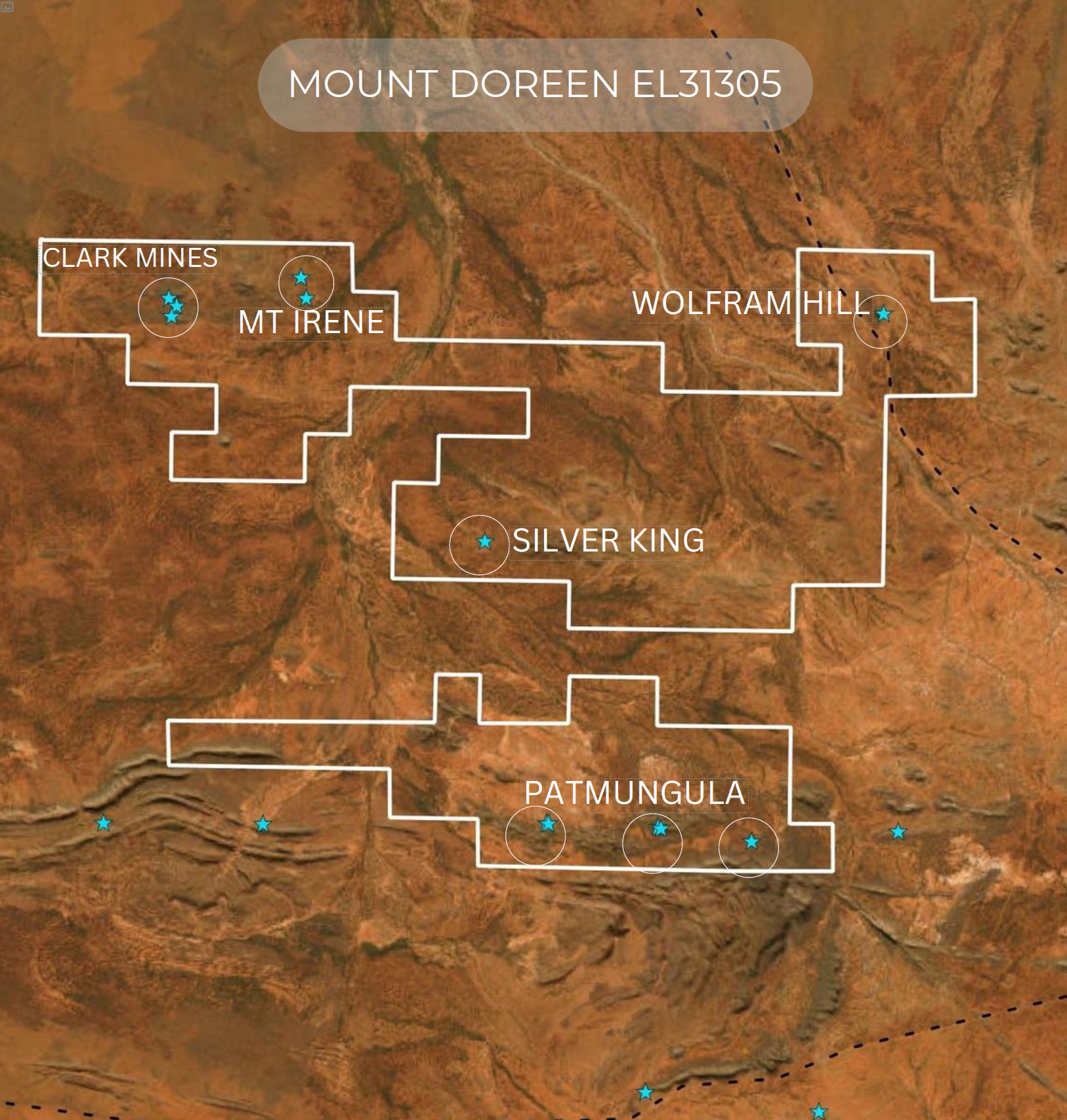
- Tenenment package – The Mount Doreen tenement package consists of 5 highly mineralised areas known as:
- Silver King
- Mount Irene
- Wolfram Hill
- Clark Mines and
- Patmungula.
- Location – only 350km north-west of Alice Springs and accessible by the newly sealed Tanami road, all six areas easily accessible by station tracks.
- Infrastructure – A fully serviced engineering camp exists nearby Wolfram Hill.
- Geology – Mineralisation across all areas varies in geological style. Most is Polymetallic consisting mainly of Copper, Lead, Zinc, Silver, Gold , Rare Earths and Tungsten.
- Road to Discovery – Good exploration database including historical and modern exploration & geophysical data. We have 6 walk up target areas to explore and drill once all clearances are in place.
- Drill Ready – Immediate drilling to commence once IPO is complete. Targets have been generated from a 2023 induced polarisation campaign.
Independent Geologist Report
Silver King
The host rock at Silver King (also known as Jubilee Silver King) is quartz-muscovite schist of the Lander Rock Formation. The schist shows complex folding with faults truncating folds and foliation in places. The schist is intruded by pegmatite and aplite dykes. The Yaloolgarrie Granite outcrops 4km east of the prospect.
The Silver King prospect comprises several small workings over a mineralised area of 60m by 50m The main mineralised zone at the prospect is considered to be located in the hinge of a large fold. Mineralisation strikes 315° magnetic and appears fault bounded by east-west features.
The mineralisation at Silver King has been described as vein and quartz-rich greisen associated with siliceous and iron alteration and spatially associated with aplite dykes and pegmatitic segregations or leached porphyry veins. The mineralised zone is leached and silicified with some suggesting this is related to a porphyry system. The polymetallic metal assemblage, molybdenum-bismuth enrichment, and fluid inclusion studies are also consistent with a granite-related system. At the surface, various oxidised lead, copper, bismuth and iron carbonate, sulphate and oxide minerals are present.
Early Bureau of Mineral Resources (BMR) and Commonwealth Scientific and Industrial Research Organisation rock chip sampling of mineralised material across the workings include 16 – 55% Pb, 11 – 31% Cu, and 140 – 1,490 ppm Ag (Warren et al., 1974).
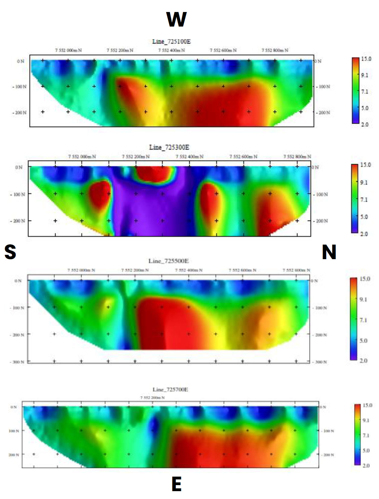
Silver King IP Results
Five gradient IP lines were conducted over the Silver King area, spaced at 200m each line. The gradient array came back highlighting an 800m long chargeability anomaly Four NS lines of Pole Dipole were then completed PDIP lines spaced at 200m.
The chargeable zone is dominated by a very chargeable 26 mV/V) anomaly which is coincident with historical workings The resistivity is dominated by EW trends and seems to represent a large fault over the entirety of the area.
- Line 725100E – Low resistivity cover layer around 30m deep sitting over a very resistive basement. It has a Fault like sub vertical lower resistive zone at 7552140N. It has a broad diffuse of moderate chargeability zones. This zone starts from 50m, its up to 600m long, and appears to go down past 300m.
- Line 725300E – Dominated by discrete highly chargeable zone at surface which appears to be 200m long by 100m deep. There is a broad chargeable zone to the North and some secondary high chargeable zones to the south.
- Line 725500E – Low resistivity cover layer around 30m deep sitting over a very resistive basement. It has a Fault like sub vertical lower resistive zone at 7552140N and a broad diffuse chargeability zone in the centre of the line. This zone starts from 50m, is up to 600m long, and appears to go down past 300m.
- Line 725700E – Low resistivity cover layer around 30m deep sitting over a very resistive basement. It has a Fault like sub vertical lower resistive zone at 7552180N. There is a broad diffuse chargeable zone to the northern part of the lines which appears to start at 100m, with 400m of length and potentially 300m of depth.
Mount Irene
The host rock at Mount Irene is the Lander Rock Formation. Mount Irene workings comprise two parallel quartz-veined shears. Copper oxide minerals are present in working dumps.
Tanami Gold rock chip sampling at the Mount Irene workings returned a best result of 0.35 g/t Au over a 0.7m wide composite. Lag soil geochemistry was completed over the area to a 1,000m x 100m spacing, returning several low values to a maximum of 7 ppb Au. Later 2004 rock chip sampling east of Mount Irene returned no anomalous results.
In October 2019 Litchfield collected four rock chips from workings at Mount Irene that were analysed by ALS Laboratory for multi elements and gold. Results included up to 35.8 ppm Ag, 24.2% Cu, 2,930 ppm Pb, 1.3% Zn and 0.56 ppm Au.
Later rock chip sampling in May 2023 included pXRF scanning of 64 rocks, which pointed to anomalous newly discovered, vanadium with anomalous levels of tungsten, tin, lead, and zinc. Copper results showed a consistently high tenor.
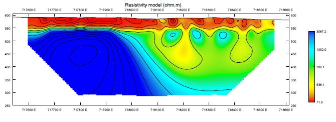
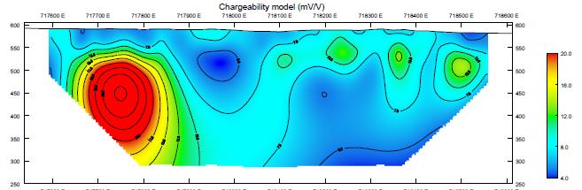
Planetary Geophysics conducted an 11-line GAIP survey over the Mount Irene copper workings in May 2023. The lines were spaced 100m apart and at a minimum of 1 km long. A chargeability anomaly in the northwest corner of the surveyed area was followed up with a one line 1 km length PDIP survey.
A large highly chargeable body of 150m depth was defined, situated in a highly resistive zone, which may sometimes overestimate the chargeability response. The anomaly was not completely defined as it is located at the western end of the PDIP line.
Moderate to strong malachite and azurite, and massive spongy gossan and Fe stone is common within the outcrops and pit walls. Minor brecciated and boudinaged ferruginous quartz veining occurs in the area, however most outcropping surficial mineralisation appears to be stratiform and strongly lateritised.
Gold anomalism have been identified by previous explorers in rock chips, with soils to 160ppb and stream sediments to 9ppb.
Mount Irene IP Results
Five gradient IP lines were conducted over the Mount Irene area initially, after which we completed a Pole Dipole line over an area which showed high chargeability. This area appears to be open to the west and more lines will need to be done.
The Pole Dipole line has shown several small, shallow sources through 718100E to 718500E. These sources appear to marry the known surface mineralisation.
The large highly chargeable body at 717750E starts from 50m and has its core about 150m deep, 400m long & looks to extend down past 300m. This anomaly is not completely defined and needs to be closed off to the west to better gauge this result.
Wolfram Hill
Wolfram Hill is in the northeast corner of the tenement package and consists of two prominent hills, with mineralisation occurring mainly on the eastern side of these hills. The host rock is lower amphibolite facies metasedimentary biotite-muscovite-andalusite-quartz schist and minor metasandstone of the Lander Rock Formation.
The rocks are tightly folded and the sandstone members have fractured and thus provided sites for pegmatite emplacement. The metasediments are intruded and cross-cut by numerous quartz and pegmatite veins running parallel to each other in a northwest-southeast direction.
Tungsten and copper mineralisation at Wolfram Hill is hosted in two main reefs of pegmatite and quartz. The pegmatites range up to 100m in length. Mining activity has been concentrated on the northeastern limb of the fold.
Mineralisation largely comprises wolframite with minor scheelite associated with malachite, azurite, minor chrysocolla and tungstite. Other economic minerals reported include chalcocite, chalcopyrite, anglesite, pyrite, limonite, linarite, cerussite, brochantite, siderite, galena, wulfenite, argentite, and gold.
The wolframite occurs as coarse grains in quartz veins, micaceous seams, and pegmatitic quartz-mica segregations; hydrothermal alteration zones of bleached quartz-sericite rock that surround the pegmatites.
Clark Mines
The Clark copper workings are located 30km west of Wolfram Hill. The prospect geology includes phyllites of the Lander Rock Formation and gneissic granite. The metamorphic rocks have a strike orientation of 065° to 080° and dip steeply northwest.
The three pits lie along strike of a quartz-veined shear zone that strikes east-northeast several veins of quartz and pegmatite cut the phyllite and granite, and copper minerals occur in three of the veins. Mineralisation consists of malachite, azurite and minor chalcocite in the oxidised zone, with pyrite and chalcopyrite in the sulphide zone.
In 1970 the NT Mines and Water Resources branch undertook geological mapping, rock chip sampling, and drilling at Clark (Fruzetti, 1971). Six diamond holes totalling 282.5m were drilled with maximum analyses reported of 3.6% Cu, 0.14% Pb, and 0.6% Zn. At the time, the Clark workings were estimated to contain 2,800t of broken material at surface grading 7% Cu and 5,700t of material grading 2 – 3% Cu.
Homestake Gold in 1997 undertook regional soil and stream sediment sampling that outlined an anomaly 1.5km long over the Clark workings, and a 500m long anomaly, 1km south. Rock chip sampling returned up to 1.52 g/t Au and 19.7 % Cu.
Our team plans to swiftly initiate geophysical studies in this area to identify potential drilling targets. Our approach includes conducting induced polarisation surveys across the entire area, complemented by an aeromagnetic campaign. Technically, the area is prepared for drilling and is encompassed in our Mining Management Plan (MMP), which permits us to drill up to 10 holes and carry out extensive geophysical activities.
Patmungula
Prospecting at the Patmungala Cu and Pb shows returned rockchip results up to 6.2% Cu, 190ppm Pb and massive pyrite containing 15-20ppb Au. The geology and Cu-Pb-Zn-Ag-Au association suggests a VHMS origin.
At the known copper occurrence, mineralisation is within a chert-vitric tuff horizon over a 200m strike length. The minerals are mainly malachite and azurite with some cuprite, and appear to fill a large tension gash. Largest working trench is 10m long, which has only tested less that one meter in width which yielded up to 6.2% copper with unmineralised wall rock reporting a maximum of 1030ppm
The Lead prospect which is 4.5kms to the east is represented by small pits within a 50m wide zone of vitric tuffs where disseminated galena occurs in thin bands. North of the Vitric tuff zone an abundance of volcanic related sediment float, lo sub-outcrop and quartz veining occur between outcrop areas of Patmungala beds.
Roebuck conducted reconnaissance rock chip sampling. The copper occurrence returned up to 6.2% Cu and trace Ag and Au. A sample of the galena bands at the lead occurrence assayed up to 1,900 ppm Pb. Additional ferruginous, mainly carbonate rich horizons were noted but not sampled. Visible Cherts which was tested sub 1m in width assayed 10% pyrite.

Mount Doreen Photo Gallery


